North and South Andaman
Wednesday, 07 July 2010 05:24
administrator

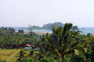
NORTH ANDAMAN ISLANDNorth Andaman Island is the northernmost island of Great Andaman of the Andaman Islands, with an area of 2,781 km². The main town on the island is Diglipur. Known for its marine life, the island's main industries are rice and orange-growing. The island is home to the highest point in the archipelago, Saddle Peak at 738 metres. North Andaman experiences fairly frequent large earthquakes and suffered inundation from the 2004 Indian Ocean earthquake tsunami. North Andaman is one of the five chief islands located to the north of Andaman District, Andaman and Nicobar Islands. Lying at an altitude of 738 m above sea level, the island spans an area of about 2780 sq km. It is a sub division of North Andamans and covers a total of 607 km of shoreline. Main attractions are Saddle Peak, Cadell Bay and Turtle Islands. To the extreme north of this island, is Landfall Island. |
|
|
|
SOUTH ANDAMAN ISLANDSouth Andaman Island is the southernmost island of the Great Andaman and is home to the majority of the population of the Andaman Islands. Port Blair, the capital of the islands, is located on the southern part of this island. Some areas of the island are restricted areas for non-Indians; however, transit permits can be obtained from the Home Ministry. Like the rest of the archipelago, it was struck by the 2004 Indian Ocean earthquake, leading to many deaths on the island. South Andaman is the third largest island in the island group. It is located immediately south of Middle Andaman Island, from which it is separated only by a narrow channel, a few hundred meters wide. The island is 93 km long and 31 km in width. Its area is 1348 km². It had a population of 181,949 as of the 2001 census. South Andaman is less mountainous than the more northerly of the Andaman Islands. Koiob reaches a height of 456.6 meters. |